Mountain Climbing in Tanzania

Mount Kilimanjaro Overview


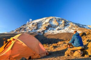
Climbing Kilimanjaro is the experience of a lifetime. It’s certainly not hard to see why this climb tops bucket lists around the world. The mighty Mount Kilimanjaro is the highest mountain in Africa at a staggering 5,895 metres (19,341”), and the world’s highest free-standing mountain. Though many of the mountain’s routes are not for the faint-hearted, with an experienced guide at your side, you certainly don’t need to be an experienced climber to reach its summit.

Kilimanjaro national park is a popular destination for travelers who are up for a challenge. Here we delve into everything you need to know about your Mount Kilimanjaro climb, from our best recommended Kilimanjaro itineraries to how to the practicalities of preparing for the adventure of the lifetime.


Kilimanjaro itineraries


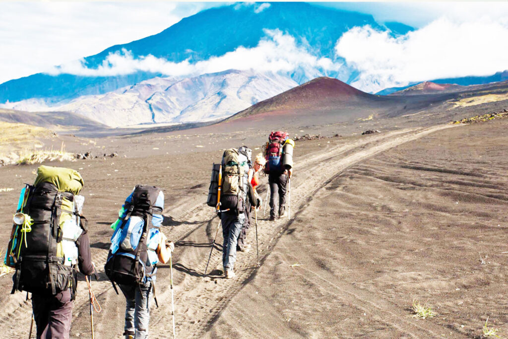
Once you’ve made the decision to climb Mount Kilimanjaro, the next step is to choose the best route for you. There are a total of seven main Mount Kilimanjaro routes which lead to the summit. One route begins on the Northern side of the mountain and the remaining six begin on the Southern side. Tanzania Specialist offers climbing Kilimanjaro itineraries for all the different Kilimanjaro Routes.


The main question is which route should you choose?


Kilimanjaro climbling routes:


Best for beginners – Marangu or Machame Routes
Spectacular scenery – Lemosho or Machame Routes

Beginners with a budget – Marangu Route

For moderate hikers – Machame or Lemosho Routes

Expert hikers – Umbwe Route

Most popular Mount Kilimanjaro route – Machame Route

Longest Mt Kilimanjaro route – Northern circuit

During rainy season – Rongai Route

Highest success rate? – 8 days Lemosho Route or 9 days Northern Circuit


Ol Doinyo Lengai Mountain


Ol Doinyo Lengai volcanic mountain stands at altitude of 2962 meters (9711 feet) above sea level, is a unique and extremely captivating volcano that towers above the East African Rift Valley in Northern Tanzania, just south of Lake Natron. It is the only volcano in the world that sometimes erupts natro-carbonatite lava, a highly fluid lava that contains almost no silicon. Natro-carbonatite lava is also much cooler than all other lavas, at about 950 degrees F (510 degrees C) compared to temperatures over 2000 degrees F (~1100 degrees C) for basaltic lavas. Natro-carbonatite is the most fluidity lava in the world. Lava with a low gas content can flow like a whitewater stream, and actually has a viscosity near that of water.Natro-carbonatite lava glows orange at night, but is not nearly as bright as silicon-based lavas since it is not as hot. During the day it is not incandescent, most flows look like very fluid black oil, or brown foam, depending on the gas content. In the past, some visitors to the crater believed they were seeing mud flows. Most newly solidified lava is black and contains crystals that sparkle brightly in the sun.


There are also sometimes small flows known as “squeeze-ups” that are light gray when they flow and harden. Contact with moisture rapidly turns natrocarbonatite lava white because of chemical reactions that occur when the lava absorbs water. Eventually the water absorption process turns lava flows into soft brown powder. During dry weather the whitening of flows happens over a period of a few days to a couple of weeks, depending on the thickness of the flow. In rainy weather the lava surface turns white immediately.


In parts of the crater that have been inactive for several months, the ground is light brown/white and so soft that one sinks into it when walking. Ol Doinyo Lengai also has phases of explosive activity during which the composition of the lava may contain much more silicate material, reducing its viscosity. In this type of eruption there is no fluid lava and activity takes the form of ash eruptions accompanied by ejection of blocks and bombs. However, initial phases of an explosive eruption may include strong lava fountains.


The two most recent explosive eruptions occurred during 1966-1967 and 2007-2008.


Since the mid 1980’s, lava flows, and to a much lesser extent, explosive eruptions, have been witnessed by many observers of Ol Doinyo Lengai. Natro-carbonatite lava eruptions are usually centered in one or more small cones that have been formed on the crater floor by previous eruptions of lava. These eruptions have typically taken the form of open lava pools or lakes that may or may not be overflowing, lava flows issuing from holes or cracks inside or near the base of the cones, or lava splashes or fountains from the summit vents of the cones.


Mount Meru


At a height of 4,566 meters (14,980 ft), Mount Meru is a dormant stratovolcano located in Arusha National Park, 70 Kilometres (43 miles) west of Mount Kilimanjaro in the country of Tanzania. Typically Mount Meru Climb takes four days, but it can be done in 3 days to complete a trek to the Summit.

It is visible from Mount Kilimanjaro on a clear day, and is the fifth-highest mountain in Africa, dependent on definition. Climb Mount Meru, Second highest Mountain in Tanzania, is great with no traffic and amazing wildlife experience as you hike past wild animals.


Mount Meru Key facts

1. Tanzania’s second tallest mountain at 4,566m
2. Abundant wildlife sightings on day 1 of the climb
3. Great acclimatisation climb before tackling Kilimanjaro
4. Ascent and descent via the Momela route over 3 days
5. Dormitory style hut accommodation


While Mount Kilimanjaro the highest mountain in Africa gets the bulk of the attention when it comes to climbing in Tanzania, there are other peaks that are worth considering too. Most prominent amongst them is Mount Meru, which is found a short distance to the west of Kilimanjaro and serves as a great warm-up trek for those who have the time and are looking for an even bigger adventure. Mount Meru climbing is very rewarding.

Standing 4565 meters (14,980 feet) in height, Mt. Meru is a more approachable climb than Kilimanjaro and serves as a great stand alone hike in its own right. Many trekkers choose to use Mount Meru as an acclimation hike prior to starting their trek up Africa’s highest peak.


Usambara Mountains


Usambara is a beautiful mountain range with grassy plains and virgin tropical rainforest. The area has many colorful villages you can visit during your stay here. The Usambara mountains are located northeastern Tanzania, near Mkomazi National Park, about 3 hours’ drive (110 km) west of Tanga.

It is one of the undiscovered places in Tanzania. And this is what makes it a true paradise for nature and hiking lovers. The lush green mountains have a cool climate that is ideal for walks and hikes. But one of the best reasons to hike the Usambara Mountains is the amazing view. You’ll see sweeping hills, mountains, valleys, farmland, picturesque villages, colorful markets and plantations everywhere you go.

The Usambara Mountains comprise the easternmost ranges of the Eastern Arc Mountains. They are 90 km long and about half that wide. Faulting and uplifting formed them nearly two million years ago, and they are composed of Precambrian metamorphic rocks.

Birds in Usambara

Usambara Mountains are very unusual in East Africa with their natural regions still covered in tropical forests and therefore they are considered a tremendously significant ecologically and a biodiversity hotspot with many protected zones. Several species are living in the Usambara forests, including the Usambara eagle-owl, the Usambara akalat, the Usambara weaver and the African violet. You can also spot other bird like the Mountain buzzard, Crown eagle, Eastern bronze-naped pigeon, Lemon and Dusky turtle dove and the Hartlaub’s Turaco.

Flora and Fauna found in the Usambara Mountains

You can find over 3000 plant species and over 600 tree species that thrive in the Usambara Mountains. Therefore it is known as one of the world’s biodiversity hotspots. It here fore attracts naturalists and nature lovers from all over the world who come to watch birds, study trees and flowers or butterflies. Several species are endemic to the Usambara forests.

Udzungwa Mountains National Park


The Udzungwa Mountains National Park is a beautiful area in the southern part of Tanzania. It has various habitats such as tropical rainforest, mountain and miombo forest, grassland and steppe. There are more than 400 species of birds, thousands species of plants and six species of monkeys – including the rare Iringa red colobus and the Sanje crested mangabey. These two types can only be found in this region. The Udzungwa national park has the second largest biodiversity of any national park in Africa. A very interesting national park to visit during a Tanzania Safari!


Udzungwa Wildlife

Udzungwa Mountains has a good variety of wildlife. They are home to many animals, including Abbott’s duiker, Kipunji and unusual animals such as the grey-faced sengi . Elephants are living in the forests along the southern escarpment. Also six registered primate species call Udzungwa national park their home. The Iringa red colobus and the Sanje crested mangabey live only in this area and nowhere else in the world! The latter, remarkably, remained undiscovered by biologists before 1979.


The Kihansi spray toad lives around a waterfall on the Kihansi River. It was briefly extinct in the wild in 2009 when an upstream dam altered its habitat. Scientists successfully managed to reintroduce them back after a successful captive breeding program.


Birds in the National Park


As a bird lover you will be drawn to Udzungwa Mountains National Park for its abundance of birds, which includes more than 400 species. Bird-watchers regard the area among the top three African mainland bird conservation areas.


Some of the bird species in Udzungwa include the African marabou, crowned eagle, Ruppells vulture and the African hobby. Scientists discovered the Francolin and Rufous-winged Sunbird only in the last few years. It also hold species such as Dappled mountain-robin, Sharpe’s akalat, Olive-flanked robin-chat and White-chested alethe. The Udzungwa forest partridge was only discovered in 1991 and is a species, with its closest relatives appearing to be the hill partridges of Asia.


Climate in Udzungwa


Most of the rainfall occurs in the November and March-to-May wet season, although mist and light rain occur at higher elevations during the dry season months. Temperatures are cooler at higher elevations. A visit to the park is not recommended in the rainy season. Best time is June to October.


Travel time to Udzungwa National Park

  • From Dar Es Salaam to Udzungwa: 6 hrs
  • Udzungwa to Mikumi: 1.5 hrs
  • To Ruaha: 6-7 hrs by car
usambara mountain
mount oldoinyo lengai

Ask Our Expert

Scroll to Top